
Stage II fire restrictions are in effect. Generator use is prohibited from 9 a.m. to 8 p.m.
There is currently no drinking water at the park. Restrooms and showers are fully functional.
Trails
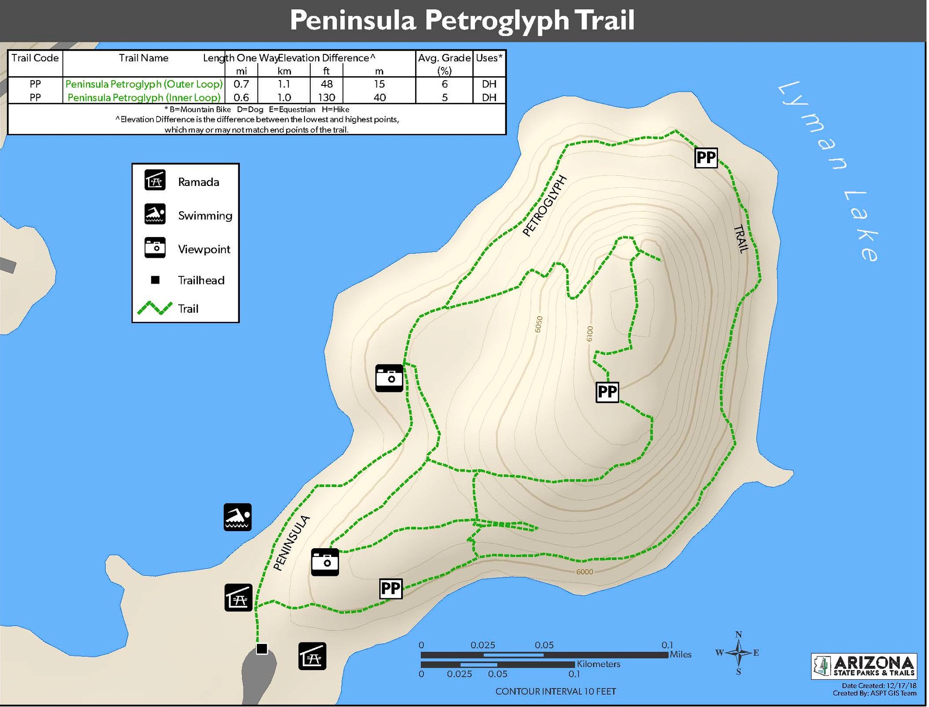
 Peninsula Petroglyph Trail: This 0.7-mile self-guided trail is accessible from the campground and is open during daylight hours every day. The trail requires a mild climb and is rated moderate. The loop trail leads around the outer edge of the hill providing 360° views of the lake, or hikers may make the quarter-mile trek to the top of the hill to a scenic viewpoint. The trail also connects to an inner hill loop trail, and a scenic viewpoint loop, totaling approximately 1.5 miles of trail around the edge and top of the hill. Tour the trail.
Petroglyphs ("rock art" or pictures carved on stone) and interpretive signs are easily visible from the trail, making this hike one of the most popular in the park. The petroglyphs originate from the Hopi people and there are more than 200 viewable directly from the trail on this hike alone. Read more about this history below. Please join us in being a steward of this irreplaceable cultural history. Do not scratch or deface the petroglyphs in any way. Prepare for your visit by learning how you can play a part in historic preservation HERE.
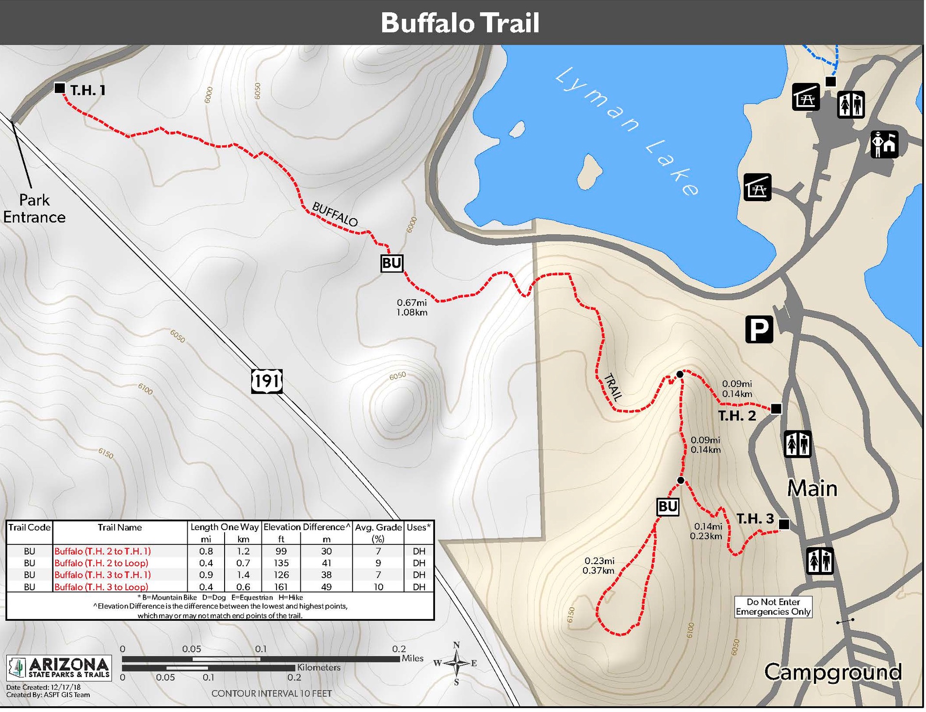
Buffalo Trail: This trail is approximately two miles in length, accessible via three trailheads, and is a moderately strenuous hike, involving some steep, vertical inclines and steps. It is named for a group of bison that were kept near the front entrance in the 1970s. Today, this trail offers scenic views of the campground and lake. See the map below for the trailheads located at the park entrance and on the north and south end of the “C” campground, close to sites 18 and 25. Tour the trail.
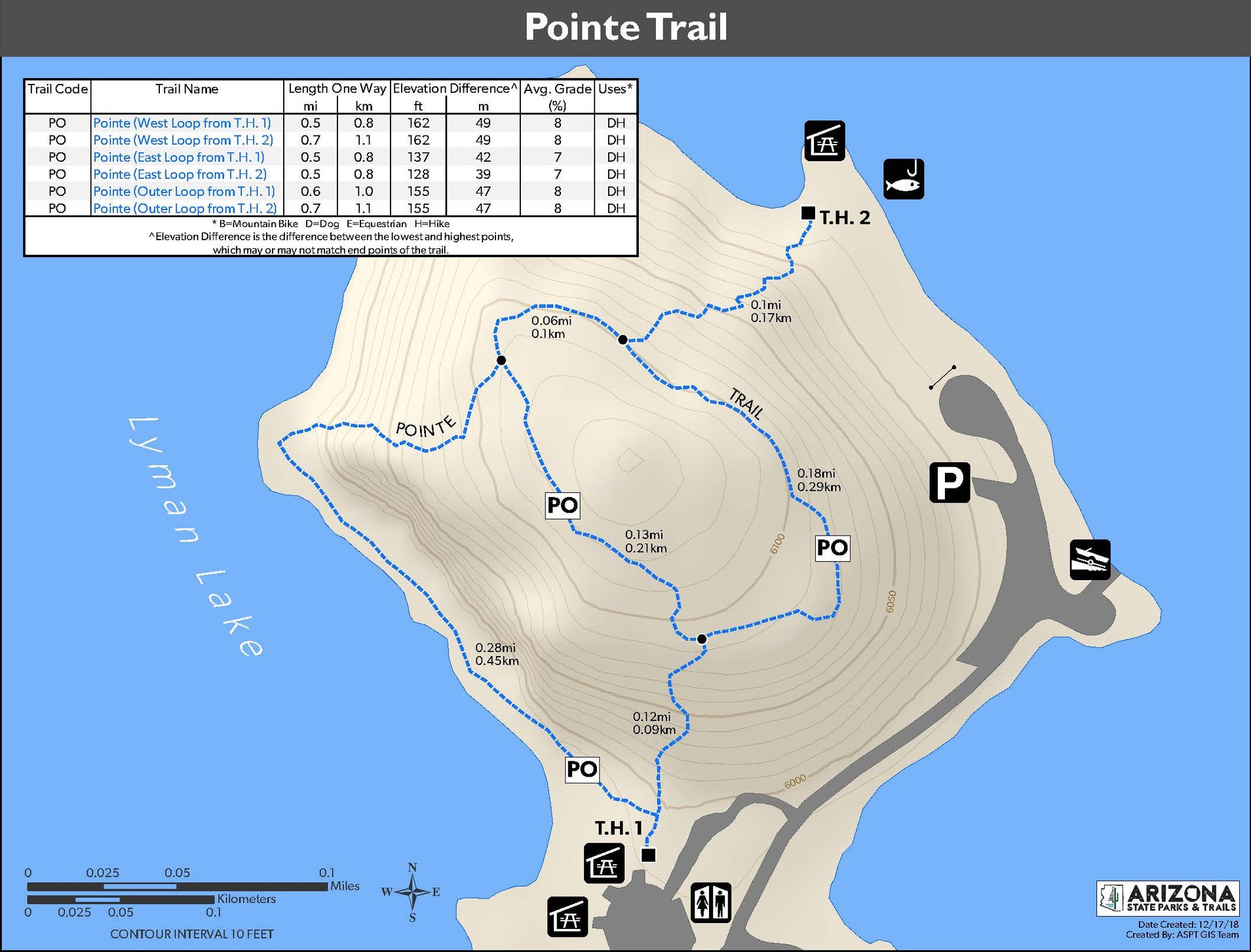
Pointe Overlook Trail: This short trail is approximately one mile long but is considered moderately strenuous due to the inclines and steep stairway at the beginning of this trail. On the way and at the top of the pointe, hikers are rewarded with incredible views of the lake. It starts at the north end of the day use area and joins two loops on top of the hill that overlooks the pointe near the group use area. Access the trailhead across the street from the park's General Store and to the left of the bathroom—the trail is tucked up against the hill (see map below). Tour the trail.
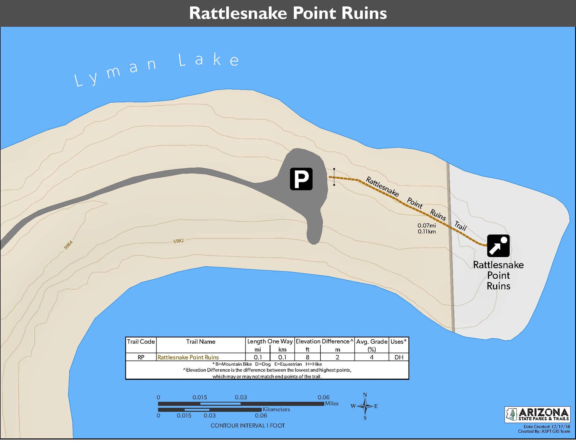
Rattlesnake Point Pueblo: Rattlesnake Point Pueblo is located at the end of a brief 0.07-mile pathway leading straight to 3 excavated rooms of an 80+ room pueblo that the ancestors of the Hopi people lived in. The pueblo is believed to have been occupied from approximately 1325 AD to 1390 AD. Be mindful of your impact as you visit so we can preserve this irreplaceable cultural history well into the future. Please do not step over the chains around the pueblo perimeter or go inside the rooms, and leave any pottery and petrified wood where it was found.
Note this trail has limited public access; the gravel road leading to the pueblo is gated and closes at sunset.
Trail Rules and Etiquette: Please remain on the maintained trails and do not go off trail. Doing so can contribute to erosion or damage of historical artifacts. Take everything out with you that you carried in; do not leave trash on the trail. Campfires and camping are not permitted on the trails and must be conducted at a designated campsite. Lastly, help preserve cultural history and the natural beauty of our trails; do not remove pottery, petrified wood, plants, or rocks.
Dogs are welcome on the trails at Lyman Lake but must be on-leash at all times. Leashes should not exceed 6 feet in length. Please remember to pick up after your pet and dispose of waste baggies in a trash can at the park.
Remember to hike safely! Bring sufficient water and turn around when you are halfway through your water supply. Wear proper hiking shoes and take care on uneven surfaces. Salty snacks are recommended but please pack out all trash with you. Lastly, check the weather before you hike, and wear a hat and sun protection. Find more hiking safety tips HERE.
Hiking and History: Petroglyph Trail
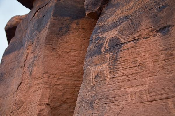 The central petroglyph is the water serpent. When Hopi ancestors were given a sign to stop and settle in an area, sometimes there would be no water. So these people, through ceremony, would pray to the water serpent underground. The water serpent, whose domain is under the ground, would answer by churning around, which would force water to seep out of the ground. Learn more by downloading the Interpretive Guide below.
The prehistoric inhabitants of the upper Little Colorado River drainage left a rich material record of their time in the valley. The ruined buildings, artifacts, and petroglyphs ("rock art") provide the scientific evidence that permits archaeologists to understand the area's prehistory. Hopi people see the abandoned houses, broken pottery, and markings on the rocks as a record left by their ancestors during the migrations described in Hopi oral tradition. Scientific archaeology and Hopi oral tradition provide two ways of assigning meaning to the physical record of human occupation of this area.
Science provides a framework for seeking testable answers to an evolving set of questions. For scientific archaeology, these questions concern past human behavior. The artifacts, the architecture, and the petroglyphs that archaeologists study provide the evidence that allows them to answer the questions they pose.
Hopi oral tradition provides, for Hopis, a different way of knowing the past. At Hopi, each clan has a narrative of its own history, from emergence, through migration, to eventual settlement on the Hopi mesas. These clan narratives, passed down in both secular and sacred contexts, together comprise Hopi history. This knowledge of the past is deeply grounded in religion, reinforced through ritual, and made apparent in ruined villages, ancient pottery, and the marks left on the rocks.
To learn more, download an interpretive guide about Rattlesnake Point Pueblo (limited public access) and the Petroglyph Trail: Download Prehistory Intrepretive Booklet. Take a virtual tour of the trail.
With so many trails throughout the Arizona State Parks network, adventure is only a short drive away. Don't forget to bring your four-legged friend along for the ride!


