
The park's restrooms are currently closed due to a construction project on the wastewater treatment facility. Porta-potties and handwashing stations are available in the meantime. Thank you for your patience as we work to improve the park experience for all our visitors.
No walk-ins, drop-offs or bicycle entries permitted: admission only by vehicle via the entry station.
Maps
Slide Rock State Park is a very popular recreation site that attracts many visitors throughout the year. Due to limited parking and a need to protect the precious resources we ask the following of our visitors:
- We ask that every visitor do their part by carpooling and keep traffic moving on the roadway to help with safety and to comply with Title 28 A.R.S. 28-873.
- To find public parking at Uptown, visit https://walksedona.com
- For safety for all visitors, coolers will be checked for glass bottles which are prohibited at the park. No amplified music is allowed so make sure you bring your ear buds!
Thank you in advance for helping us to continue our efforts in providing a wonderful outdoor experience.
Enjoy Slide Rock State Park!
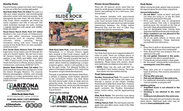
Park Location and Directions
What3Words: ///jumping.scab.orchestras
Slide Rock Park Map
Download a Printable Park Map in Spanish
Descargue un mapa del parque imprimible en español
Elevation
4930 ft
GPS Coordinates to park entrance
Decimal Degrees (WGS84)
Latitude: 34.944347
Longitude: -111.752801
Degrees, Minutes & Seconds
Latitude: N34 56 39
Longitude: W111 45 10
GPS
Latitude: N 34 56.661
Longitude: W 111 45.168
UTM 12N
X: 431258
Y: 3867130

